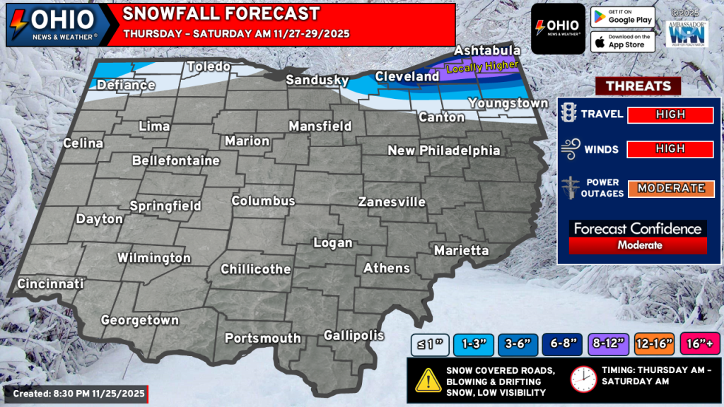
The shorter-range, high-resolution models are becoming more confident in our next lake effect snow event and have been consistent with higher snowfall totals across Northeastern Ohio. Additionally, there is more confidence of some light accumulating snowfall in far Northwestern Ohio from lake effect snow from Lake Michigan. We have adjusted our forecast accordingly.
THE DETAILS
TIMING: Lake effect snow will start between 2-5 AM Thursday morning. It will take a little time for bands to get organized but look to be more organized by the afternoon. The heaviest snow falls Thursday night and early Friday morning. Timing the end of the snowfall is a little more tricky as this is dependent on a wind shift and dry air moving into the mid-levels of the atmosphere. Currently the snow looks to end sometime early Saturday morning.
TEMPERATURE: Temperatures will be cold and range from approximately 25-30°F.
WINDS: Hang on to something! Winds will initially be from the West at 15-25 MPH with gusts to 40-45 MPH possible. By Thursday night, winds shift to the Northwest at 10-20 MPH with wind gusts to 30 MPH possible.
WIND CHILL: It’s going to feel like winter out there…. And look like it too. Wind chill values will be in the 15-20°F range. BUNDLE UP!
SNOWFALL RATES: Several snow bands will be capable of producing 1 inch per hour snowfall rates. It’s also possible to see some banding with 2” per hour snowfall rates, especially Thursday night into early Friday. Locally higher snowfall totals can be expected where snow bands persist.
IMPACTS: Travel will be significantly hampered across Northeastern Ohio starting on Thursday and persisting into Saturday night or early Sunday. Interstate 90 east of Cleveland to Buffalo will be very hazardous to drive. Local roads will be snow covered and very slippery. Travel is highly discouraged. Strong winds will create blowing and drifting snow and will reduce visibility to near zero at times.
NORTHWEST OHIO: Snow will be much lighter here but 1” to as much as 3” of snow is possible, primarily where snowfall persists. While travel will not be significantly impacted here, it could still be hazardous with snow covered roads. A general 1” to 2” of snow seems possible for most areas in far NW Ohio but will depend on exactly how the banding sets up and if it can persist long enough for snow to accumulate.
ACTION: Plan Thanksgiving travel accordingly if you will be in Northeast Ohio. Allow for plenty of extra travel time, bring extra supplies in the event you slide off the road or become stranded. Bring extra clothes and perhaps plan an overnight at a relative’s house. Use extra caution while driving and TAKE YOUR TIME.
We will continue to monitor the latest model trends and update our forecast as necessary through our website and social media pages.
Stay up to date on the latest weather alerts! Download our FREE Ohio News and Weather app on the Apple App Store and Google Play. Plus stay up to date on the threat for severe weather across Ohio on Tuesday by following us on social media.