Models are becoming more persistent with the development of Thanksgiving Lake Effect Snow as early as Thursday morning. Some of the snow could be moderate to briefly heavy, with 1 inch per hour snowfall rates possible, especially Thursday night and early Friday. Snow begins to shut down early Saturday as winds shift ahead of another system moving through later in the weekend. There may be several travel impacts across parts of Northeast Ohio this Thanksgiving.
FORECAST DETAILS
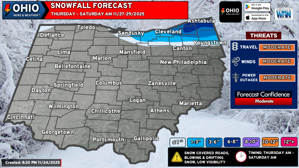
TIMING: Thursday morning through Saturday morning. With lake effect snow, it’s not very easy to pin down approximate times, especially at this range. There’s the possibility snow could start late Wednesday night, but we’re not sold on that just yet.
TEMPERATURE: Mid 20s to around 30.
WINDS: Winds will be gusty on Thursday. West northwest winds on Thursday will be in the 15-25 MPH range, with wind gusts as high as 40 MPH. Winds become northwesterly by Friday and will range from 10-20 MPH with gusts to 30 MPH. Winds die down and become southerly early Saturday morning. This will bring the snow to an end.
WIND CHILL: Anywhere form 15-25°F.
SNOWFALL AMOUNTS: Reflected by the colors on the map. In the 6-8” zone across portions of Ashtabula & Geauga counties, locally higher amounts are possible. As we approach this event, it is possible we could see higher totals across a larger area. More forecast refinement will occur over the next couple of days.
IMPACTS: Travel will be hazardous across Northeast Ohio, especially along I-90 as you approach State Route 44 and points eastward. Travel across portions of Ashtabula and Geauga counties could become very hazardous if 1 inch per hour snow bands persist. With the strong winds, visibility will be reduced to or near zero at times. Icy road conditions are also expected.
ACTION: Plan Thanksgiving travel accordingly if you will be in Northeast Ohio. Allow for plenty of extra travel time, bring extra supplies in the event you slide off the road or become stranded. Bring extra clothes and perhaps plan an overnight at a relative’s house. Use extra caution while driving and TAKE YOUR TIME.
NEXT SYSTEM: We’re sure many of you are seeing some posts from other sources about a weekend system bringing snow or even ice to the area. We are monitoring this system as well and hope to have some information to share with you on Tuesday. Models differ quite a bit on this system and you can guarantee that it will change a few more times before Friday.
We will continue to monitor the latest model trends and update our forecast as necessary through our website and social media pages.
Stay up to date on the latest weather alerts! Download our FREE Ohio News and Weather app on the Apple App Store and Google Play. Plus stay up to date on the threat for severe weather across Ohio on Tuesday by following us on social media.