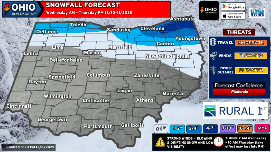
An Alberta Clipper with a potent cold front will move across Ohio on Wednesday, with lake effect snow developing by Wednesday night and persisting into at least the first half of Thursday. Snow will accumulate enough to have to move it in many spots across Northern Ohio. This midweek snowfall for parts of Ohio could create hazardous travel in some locations.
THE DETAILS
TIMING: Generally from very early Wednesday morning through late Thursday morning. Lake effect snow could linger into Thursday evening if some models have their way. There will be periods where the snow will stop for a time on Wednesday.
HOW MUCH SNOW: Higher totals in the primary snowbelt east of Cleveland and quickly tapering outside of that. Much of the northern portion of Ohio could easily see 1-2” of snow, with a few spots seeing locally more.
CONCERNS: The initial wave of precipitation may be in the form of freezing rain, sleet or a mix of the two with some snow mixed in. Some rain may also mix into everything as well. This could limit snowfall totals in spots later on. Additionally, dry slotting will occur sometime late Wednesday morning and persist for a few hours before filling back in. During this time, precipitation will generally end and surface temperatures may rise above freezing for a few hours before falling as additional snow moves into the area. Should dry air persist for longer than expected, snowfall totals could be less.
Additionally, how long the lake effect snow persists could lead to higher snowfall totals across the primary snowbelt. We will need to monitor this closely.
IMPACTS: Our midweek snowfall for parts of Ohio will create hazardous travel in some locations, especially portions of the primary snowbelt along Interstate 90. Gusty winds may create blowing and some drifting snow. Visibility will also be greatly reduced, slowing travel. Roads will become snow covered. Temperatures will also turn colder.
KEY TAKEAWAY: This is our first forecast. WE EXPECT CHANGES IN OUR NEXT FORECAST. Not all the snow will fall in a short time nor will you see the top end of our snowfall ranges in every location.
Stay up to date on the latest weather alerts! Download our FREE Ohio News and Weather app on the Apple App Store and Google Play. Plus stay up to date on the threat for severe weather across Ohio on Tuesday by following us on social media.