As our next system enters the area overnight, we’ll see snow, mix with and then change to rain on Wednesday before changing back to snow late Wednesday afternoon and evening. A transition to lake effect snow will occur Wednesday night and persist through the day on Thursday. However, there remains some uncertainty in this system, even as it’s about to impact the area. However, the forecast for midweek snowfall for Ohio is far more complex than that. Read on for details.
THE DETAILS
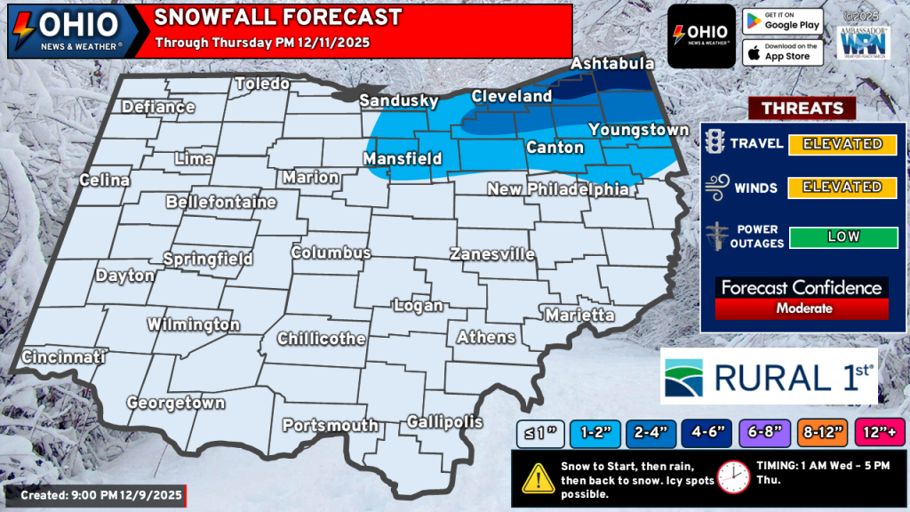
TIMING: Generally from 2 AM Wednesday through late day Thursday. A transition to rain occurs early Wednesday morning before transitioning back to snow around mid afternoon. Lake effect bands will need to set up and may not affect the entire snowbelt. These may persist in one spot or drift in an area.
CONCERNS: Dry. Air. That dreaded dry air. Dry air in the mid levels (approximately 5,000 to 10,000 feet) could weaken lake effect snowfall and some of the synoptic snow. Dry air in the low levels (generally below 5,000 feet) could also aid in weakening the overall snowfall, contributing to smaller and drier snowflakes. This gives a limited area for snowflakes to grow (the dendritic growth zone or DGZ). However, models differ on these setups. We’ll need to monitor this throughout the day Wednesday.
Warm air is another concern. Highs around or in the low 40s for parts of Northern OH are expected as the dry slot moves through the area. These warm temperatures only last a couple hours before quickly dropping below freezing with the passage of an arctic front. It’s possible that temperatures could be warmer than modeled (which seems to be the care more often than not with these setups). This would mean early snow would transition to rain sooner, warmer temperatures and rain would persist longer and while everything. In any case, this is a very tricky scenario as minor changes will result in differing impacts in either way. On the flip side, if temperatures stay on the cooler side, this could mean that parts of the area wouldn’t see rain but instead a wet, slushy snowfall.
IMPACTS: Slippery roads Wednesday morning across Northern OH where early snow persists. This will be a wet, slushy type of snow. Driving in this type of snow is hazardous as it likes to stick to just about everything. Gusty winds will blow the snow around and reduce visibility. Some minor drifting is possible Wednesday night. Some soft hail or graupel is also possible Wednesday afternoon.
Snow bands inland across the rest of Ohio late Wednesday could create brief bursts of moderate to heavy snow. This would reduce visibility and create quick snow accumulations up to 1″. Travel through these bands could be briefly hazardous.
SNOWFALL TOTALS: The highest totals will be found across the primary snowbelt east of Cleveland WHERE SQUALLS PERSIST. Elsewhere, lower amounts are possible. Snow squalls are possible just about anywhere Wednesday evening as the clipper moves out of the area. These could produce quick bursts moderate to briefly heavy snow, reducing visibility and producing a quick coating to ½” of snow accumulation. Lake effect snow bands may vary at times due to shifting winds. Eventually, dry air aloft will win out Thursday evening, bringing lake effect snow to an end.
In the end, our midweek snowfall forecast for Ohio is a very complex and dynamic forecast with no right answer. While we have decent confidence in this forecast, there’s a decent bit of potential for any forecast you see to be right… or wrong. The most important thing to focus on is to be prepared for the potential for several inches of accumulating snow in some spots, even though it may not quite pan out.
Stay up to date on the latest weather alerts! Download our FREE Ohio News and Weather app on the Apple App Store and Google Play. Plus stay up to date on the threat for severe weather across Ohio on Tuesday by following us on social media.