Synopsis
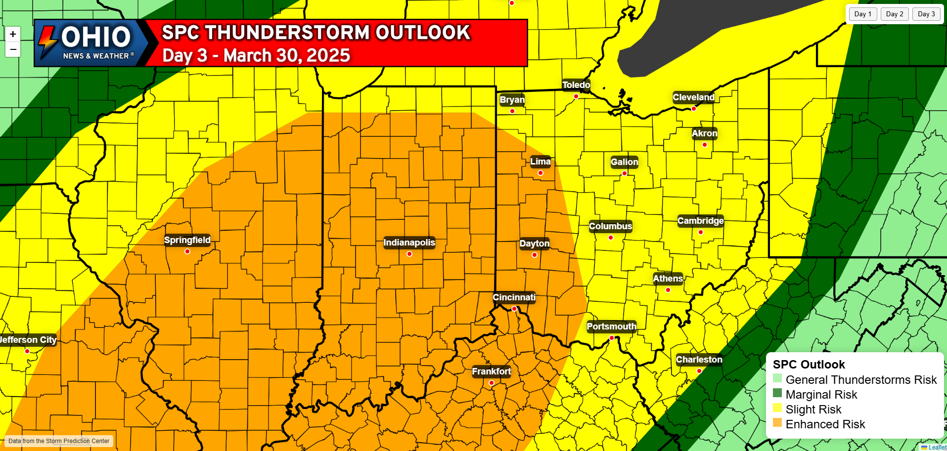
Another weekend severe weather threat is on tap for Sunday. The SPC has issued a level 3 ‘Enhanced Risk’ for portions of Western Ohio and a Level 2 ‘Slight Risk’ for the rest of the state. All hazards are possible, but the main threat appears to be damaging winds. Timing issues and a lower instability may preclude a higher threat right now, but this could and probably will change before Sunday.
Sunday March 30th, 2025
Well it is officially that time of the year again where we have regular chances for severe weather to discuss. At the moment Sunday March 30th has a pretty good chance at severe weather, and we are already looking at another chance as early as next Wednesday April 2nd . For now, let’s focus on Sunday. The Storm Prediction Center has issued an ‘Enhanced Risk’ (3/5) for part of our area, mainly Western Ohio, while the rest of the state is in a Level 2 ‘Slight Risk’. Being just a few days away, you would think we would have a pretty good grasp on what threats we’d be looking at, but you would be wrong. There are still quite a few questions we have yet to answer, so let’s go ahead and dive into those.
Instability
By far the biggest question for this entire setup, as often is the case in these parts, is how much instability1 will be present in the atmosphere for storms to work with. Instability in simple terms refers to the amount of energy available in the atmosphere for storms to use. The more instability (CAPE2) we have, typically the stronger the storms can be. For this setup, it looks like we will likely have some rain around Saturday night and Sunday morning. How fast this rain moves out and if we can see some afternoon sunshine will determine how much instability we have available. More sun = more instability.
1Instability: (abbrev. INSTBY)- The tendency for air parcels to accelerate when they are displaced from their original position; especially, the tendency to accelerate upward after being lifted. Instability is a prerequisite for severe weather – the greater the instability, the greater the potential for severe thunderstorms.
2CAPE: Convective Available Potential Energy. A measure of the amount of energy available for convection. CAPE is directly related to the maximum potential vertical speed within an updraft; thus, higher values indicate greater potential for severe weather. Observed values in thunderstorm environments often may exceed 1000 joules per kilogram (J/kg), and in extreme cases may exceed 5000 J/kg.
Wind Shear
One of the other ingredients we look for in severe weather setups is Wind Shear3 . With this particular setup, it looks like we will be in a favorably sheared environment that will be conducive for strong thunderstorms. There is not an overwhelming amount of shear which can be both good and bad, but there looks to be enough to support a severe weather threat.
3Shear: Variation in wind speed (speed shear) and/or direction (directional shear) over a short distance within the atmosphere. Shear usually refers to vertical wind shear, i.e., the change in wind with height, but the term also is used in Doppler radar to describe changes in radial velocity over short horizontal distances.
Lift
Lift is another important feature for severe weather setups or really thunderstorm development in general. One thing we look at is a value called the Lifted Index4. This helps us gauge how strong the updrafts of thunderstorms may be, and the stronger the updraft the stronger the storm. Sunday will see a good amount of lift in the atmosphere to promote healthy thunderstorm development, should all the other ingredients also come together.
4Lifted Index: (abbrev. LI)- A common measure of atmospheric instability. Its value is obtained by computing the temperature that air near the ground would have if it were lifted to some higher level (around 18,000 feet, usually) and comparing that temperature to the actual temperature at that level. Negative values indicate instability – the more negative, the more unstable the air is, and the stronger the updrafts are likely to be with any developing thunderstorms. However there are no “magic numbers” or threshold LI values below which severe weather becomes imminent.
Moisture
Simply put, storms need moisture to be able to develop and sustain themselves, and usually in the early season moisture is one of the ingredients we are lacking. You’ll hear the term Dew Point5 commonly referred to as a measure of moisture in the air. The higher that number, the more moisture that is available to storms. For this setup it looks like moisture will not be an issue, an issue as dew points will rise into the 60s which is plenty for storms to work with.
5Dew Point: (Abbrev. DWPT) – A measure of atmospheric moisture. It is the temperature to which air must be cooled in order to reach saturation (assuming air pressure and moisture content are constant). A higher dew point indicates more moisture present in the air. It is sometimes referred to as Dew Point Temperature, and sometimes written as one word (Dewpoint).
Putting it All Together
All of the above ingredients have to come together just right in order to get a significant severe weather threat. Usually one or more factors ends up not coming together at the correct time, and the threat is not as significant as it could have been or as advertised. Right now, the timing of storms, and instability seem to be our biggest questions. If storms move in earlier in the day, there may be more instability to work with, but this also requires clouds to move out and the sun to come out and heat the ground leading to that instability. In the event storms move in later in the evening or after dark, we may have more wind shear and less instability to work with, which normally leads to more of a damaging wind threat in the strongest storms. If the timing works out on Sunday, we could see an all hazards threat develop (Damaging Wind, Large Hail, Tornadoes) in the afternoon and evening hours, but at the moment damaging winds seem to be our biggest concern across the state. Western Ohio has the best chance for seeing better timing leading to stronger storms, which is why the risk category is higher there compared to the rest of the state.

Need a Weather Radio? Check out this portable FosPower Solar Powered and Hand Crank Weather Radio with Portable Power Bank!
Wednesday April 2nd, 2025
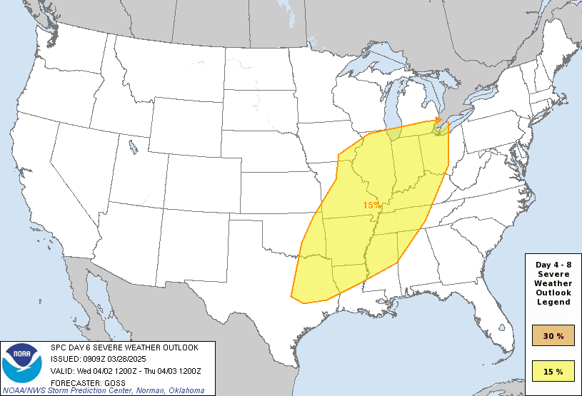
Once we get past whatever is going to happen on Sunday, we turn our attention to midweek for the next chance at severe weather. It is really too early to give anything in the way of specifics for this event. Consider this a heads up that more storms are coming and use this as an opportunity to get prepared, just in case!
Stay tuned to all of our social media accounts for the latest updates as we get closer to each event! We’ll have the latest from our team posted on our Facebook page as new information comes in!