Models continue to crank out lake effect snow like an overflowing gravy boat. Based on this morning’s data, we increased some of our totals slightly and made further refinements to the forecast.
The Details
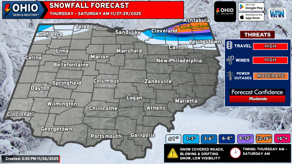
WHAT CHANGED: We are confident in a corridor of 12-16” of snow across parts of Ashtabula, Geauga, far Northern Trumbull and Southern Lake counties. Should heavy snow persist or banding remain stationary, locally higher amounts are possible, mainly in the higher terrain.
The snow gradient has been dramatically shifted. A very sharp cutoff in snow will be noted from north to south. Areas with 6-8” of snow may only fall in a narrow area and people just a few miles south could have 2-4” of snow. Going to the west (notably west of Cleveland), the gradient isn’t quite as sharp however, we are closely monitoring some modeling bringing in a robust band of snow Thursday afternoon & evening that would be connected to Lake Michigan. While it won’t be a solid band of snow, the enhanced moisture and placement of this band could bring a few inches of quick snowfall to the west suburbs of Cleveland.
TRAVEL: Let’s be honest, it’s gonna be bad. Travel will be very slow and very hazardous. Interstate 90 will be a dangerous drive all the way to Buffalo. It’s possible sections of it could close. Secondary roads will be a little worse than the highways. Strong gusty winds will create whiteout conditions at times. The snow will also drift. We recommend delaying travel, or if you must travel, allowing for a LOT of extra travel time.
NEXT SYSTEM: Models are flip-flopping on the late weekend system that moves into the region. Yesterday, models brought the track of this storm further north, which would mean rain for much of Ohio. Today, models have trended back south, which means rain for some and snow for others, and possibly some ice. Right now the consensus is a snow to rain setup from Saturday night through Sunday night. Stay tuned for more details!
We will continue to monitor the latest model trends and update our forecast as necessary through our website and social media pages.
Stay up to date on the latest weather alerts! Download our FREE Ohio News and Weather app on the Apple App Store and Google Play. Plus stay up to date on the threat for severe weather across Ohio on Tuesday by following us on social media.