We have some big changes to our forecast for the upcoming weekend winter mess. It’s a very complex system with multiple parts so let’s dive into some specifics!
Please keep in mind that this is all subject to change. We have noted differences in storm track compared to Thursday and storm track will be key with precipitation type and where the heaviest precipitation (both rain and snow) falls.
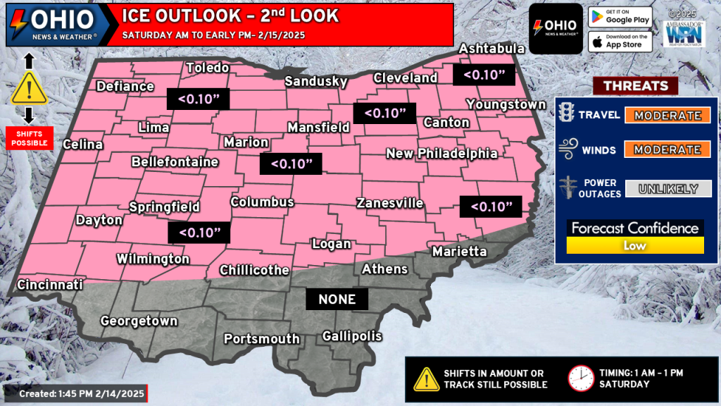
LATE TONIGHT THROUGH SATURDAY
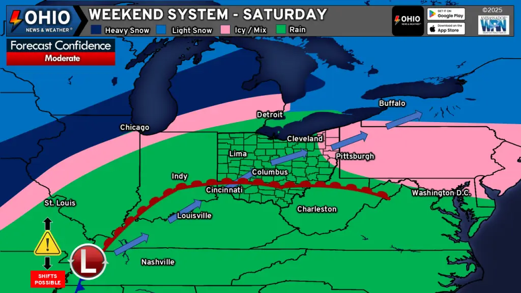
A low pressure system will begin to track into the Ohio Valley on Saturday. Ahead of it, a warm front will push northward across Ohio. Some snow will also begin to move across Northern Ohio early Saturday morning, which could allow for 1-2” of snow accumulation. We’ll then see a transition from snow to perhaps some freezing rain or a mixed bag of precipitation before all areas transition to rain Saturday afternoon. Some minor ice accumulation is possible just above anywhere, except for far southern Ohio. Ice accretion should be under 0.10” and would melt after transitioning to rain.
Rain overspreads the region through Saturday night and very early Sunday morning as the low tracks across the state. As it begins to move to the east of Ohio, cold air will flow into the region and then transition rain to snow Sunday morning. Some of the snow will be heavy at times, with 1” per hour snowfall rates possible at times in portions of Northern Ohio.
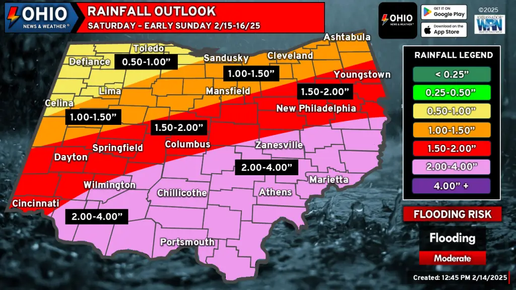
Rainfall amounts will be impressive for mid-February, with 2-3” likely across Southern Ohio. Some spots may exceed 3” of rainfall. Flooding will be possible, especially in low lying areas and along shallow creeks, streams and some rivers. Be prepared for flooding if your area is prone to it!
SUNDAY & MONDAY
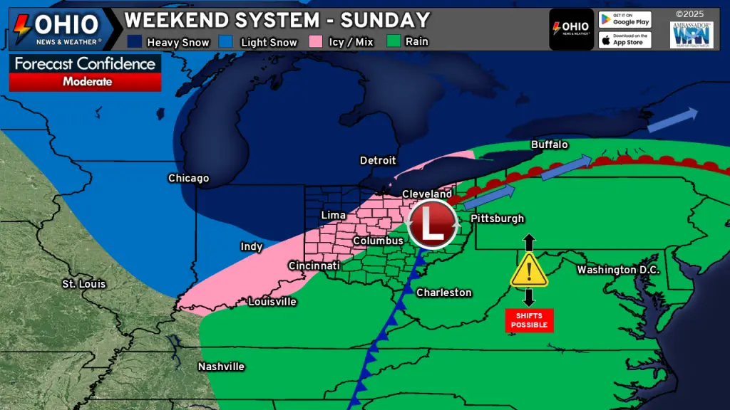
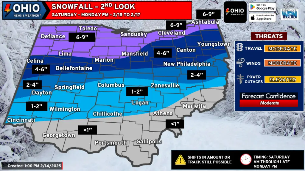
Snow will overspread a good portion of the state on Sunday, with the highest totals across Northern Ohio. Snow will begin to taper off Sunday night as a northwesterly flow will allow for some lake effect snow to set up. Yes, Lake Erie is about 90% ice covered. However, lake effect snow is still possible as the flow will allow for moisture from the other lakes, notably Lake Michigan, to provide some lake effect snow. Colder air streaming into the region will also act to “squeeze out” moisture in the atmosphere as well. Lake effect snow will continue into Monday afternoon before shutting down. We are not expecting significant snow accumulation from the lake effect, but it could add 2-3 extra inches of snow in spots.
SNOWFALL FORECAST
RAINFALL FORECAST
ICE OUTLOOK
WINDS & WIND CHILLS
Winds will pick up Sunday into Monday, generally from the Northwest at 10-20 MPH. Wind gusts could reach 30-35 MPH at times as well. Wind chills will drop into the mid teens and low 20s on Sunday and single digits Sunday night. Wind chills on Monday will be in the single digits for most and below zero across Northwestern Ohio. Be sure to bundle up!
WEEKEND WINTER MESS TRAVEL CONCERNS
Impacts to travel from this weekend winter mess will be felt from both the rain and snow. The most impactful will be the snow, with many roadways eventually becoming slick and snow covered. Use caution while traveling and allow for extra travel time.
For Saturday, some areas roadways could see flooding. Remember that if you see a flooded roadway to turn around – don’t drown. Never drive through a flooded roadway!
FORECAST CONCERNS
Some of the things we are watching that could have impacts on our forecast include:
Storm track: the exact track will have major implications on where the heaviest precipitation (rain & snow) will fall. Additionally, this could impact when precipitation changes from rain to snow, etc.
Timing: Models do differ on start times for precipitation by a few hours, but the biggest timing issue is always when the rain changes over to snow. Models differ here by 3-4 hours and that may have impacts on snowfall totals.
Dry Air: It seems when we see systems like this move across the area, a pocket of dry air works into it, eroding away some of the precipitation, whether it be rain or snow. While we see a little of this on the models on Saturday, it primarily affects the rainy portion of the system. However, that could change or prolong itself and if it does, could have impacts on rain and snow amounts.
We will continue to monitor the latest trends on this weekend winter mess and provide updates as needed. Stay tuned!