Another storm system will impact Ohio as snow & ice are on tap this Wednesday and Wednesday night. Some areas may want to break out the ice breakers or the ice skates (or both). Let’s dive into the details.
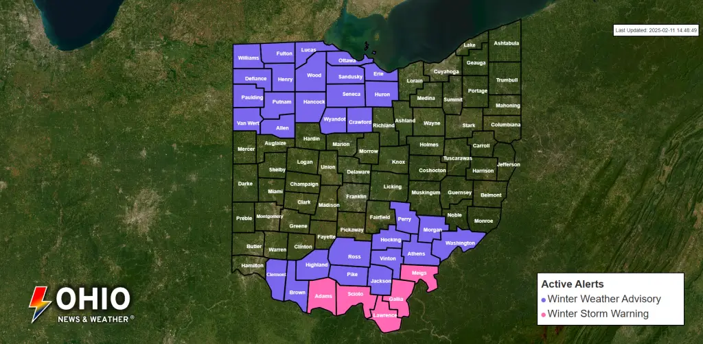
Latest Weather Alerts
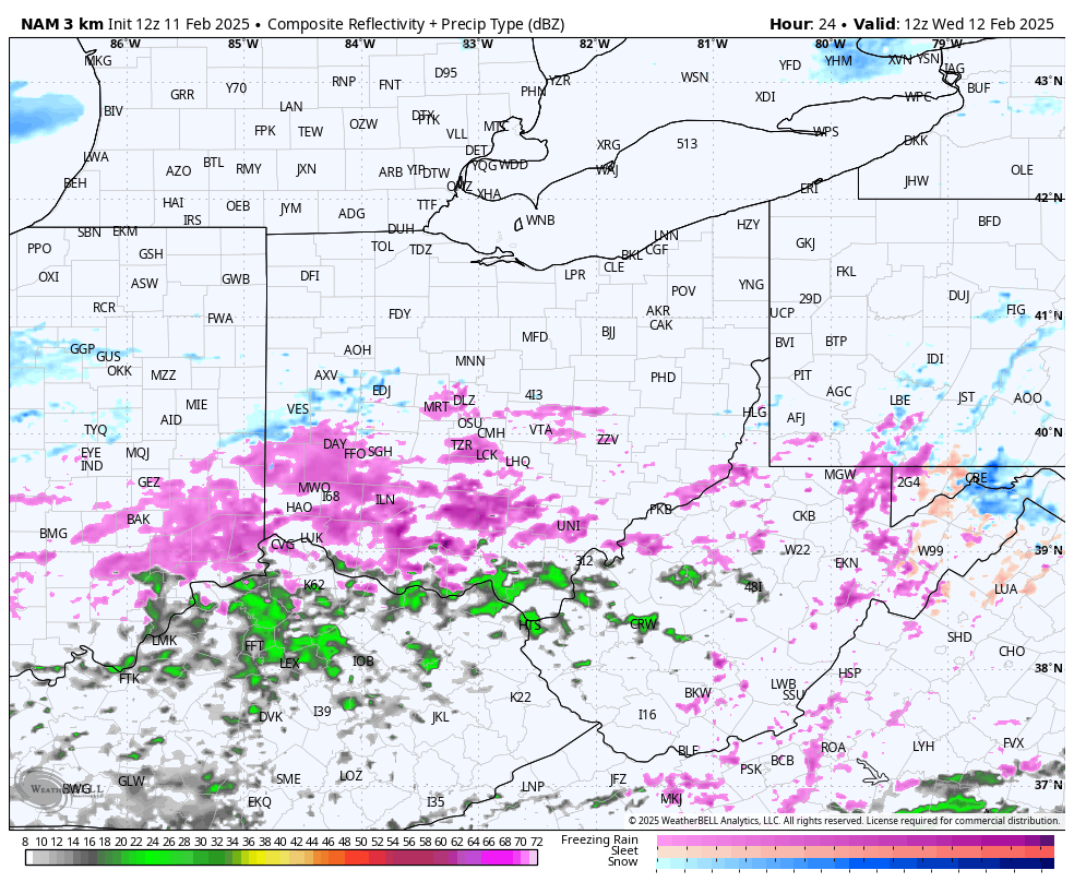
The Setup
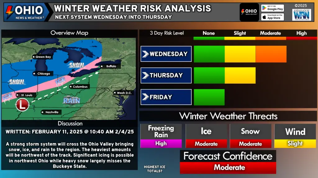
A low pressure system will track from southwest to northeast across Ohio (somewhat following I-71) on Wednesday. Colder temperatures near the surface will warm just enough for a period of freezing drizzle or light freezing rain across much of the state. There is the potential for a glaze of ice across much of Ohio by late Wednesday afternoon. Treated surfaces should have no trouble handling the precipitation however, shallow pavement and elevated surfaces such as bridges and overpasses may have some icy spots.
It’s important to know that any icy spots won’t last long as precipitation switches to all rain and temperatures rise well above freezing.
By late Wednesday afternoon, much of the freezing rain/drizzle changes over to rain. North and west of a line from roughly Port Clinton to Findlay to Celina, freezing rain will continue and will accumulate heavy enough to create hazards beyond icy roadways. Scattered power outages and the downing of tree limbs will be possible as freezing rain continues into Wednesday Night.
Across extreme Northwest Ohio, primarily across portions of Defiance, Fulton, and Williams counties, light to occasionally moderate snow will fall Wednesday night, resulting in 2-4” of snow, A little further south and east, 1-2” of snow is possible as freezing rain transitions to snow overnight.
Get the latest Watch, Warning & Advisory information here!
Latest Snowfall Forecast
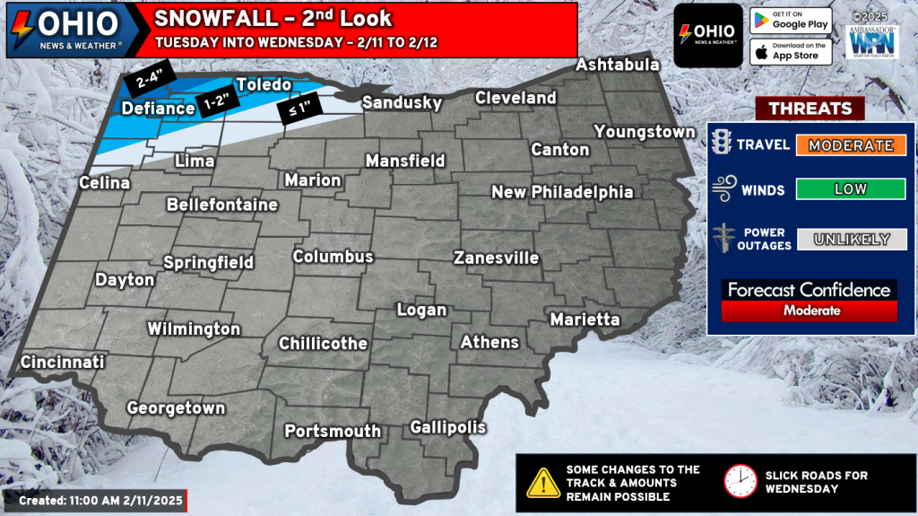
Much of the state will not see any snowfall from Wednesday’s system. The best chance for accumulating snowfall is across Northwestern Ohio, with portions of Defiance, Fulton, and Williams counties seeing 2-4” of snow. Elsewhere, around 1-2” of snow is possible for locations such as Defiance, Napoleon, Paulding, and Toledo. A little further east will see less than 1” of snow as far east as Sandusky.
Latest Ice Forecast
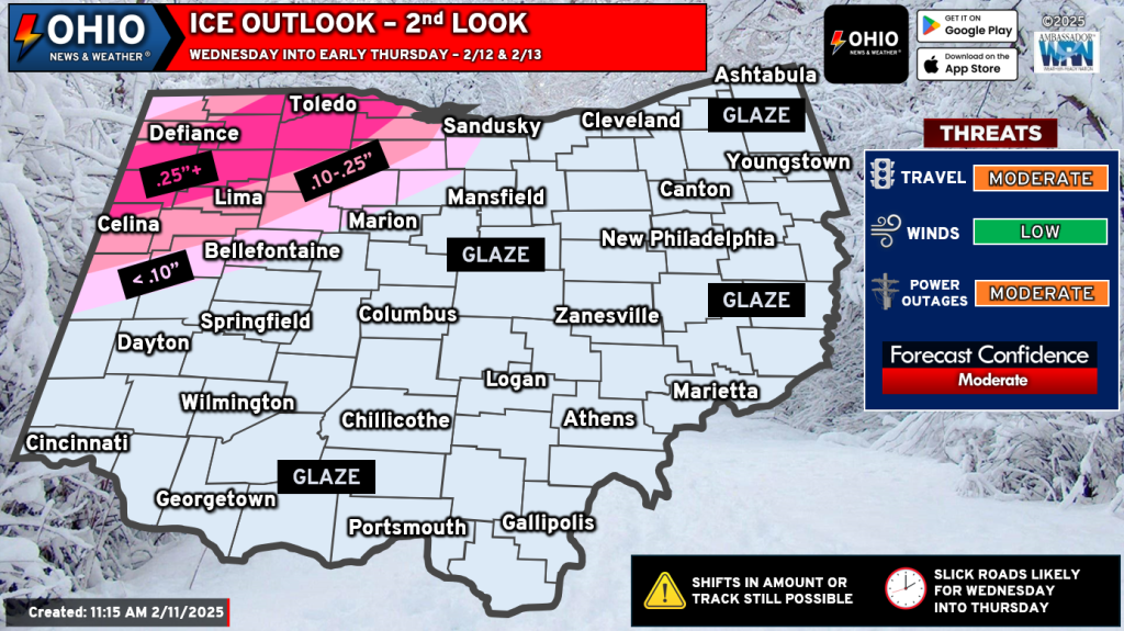
Ice will be the biggest concern on Wednesday and Wednesday night. Up to 0.25” of ice is possible across a swath of Northwest Ohio. Places like Defiance, Paulding, Toledo, Bowling Green and Van Wert could see the highest ice accretion. In other areas, 0.10” up to 0.25” of ice is possible in places like Lima, Celina, Tiffin, Fremont, and Wauseon.
Check the Latest Snow Emergencies Here!
Impacts
Besides snow and ice covered roadways, power outages are possible in spots, primarily where the heaviest ice accretion occurs. Downed tree branches are also possible. Untreated roadways will become slick and slow travel is expected. Treated surfaces will fare a little better but do keep in mind that even treated surfaces could have icy spots. Bridges and overpasses will be most susceptible to icy conditions.
The Next System
Yep – there’s more! We’ll get a break on Thursday and Friday before our next system impacts the state on Saturday and Sunday. This system may be a little more robust and will start like this system with rain, freezing rain and snow all possible. Colder air will then move in Sunday and Monday, bringing additional snow chances to part of Ohio by Presidents Day.
Be sure to stay with Ohio News & Weather for the latest updates.